I received an almost unbelievable surprise last week.
Our daughter called me to say she knew of my (amateur) love of all things geology and had booked me for a private 6-hour tour of the Central Okanagan's volcanism/glaciation sites with Dr. Murray Roed!
The tour was scheduled for Saturday, in two days!
Two days from now!
I was stunned, but excited, very excited.
I thought back to all the years I've hiked this property's uplands and came back with pockets brimming with rocks. Thirty years ago I had a very cheap camera and took photos of rocks that were interesting, saving them on Flickr, the photo storage service. My love of all things rocks went back even to childhood, when I would return from family outings with a box or two of rocks in the trunk of the car. No matter that my Mother conveniently lost the boxes over the years, but the fun was in the collecting!
And now as a 69 year old, I was going to be spending 6 hours touring exposed rocks and learning about volcanism and glaciations with a real geologist!
I pinched myself.
Up early on Saturday morning, I was oblivious to any needs beyond my own (sorry, husband! cereal is in the cupboard). A cheese sandwich popped into a Ziploc baggie was lunch, bottle of water, gloves, Kleenex, fully-charged phone, and a few bandaids (often necessary hiking or handling rocks). New Merrell hikers...check, new lightweight windbreaker with intact pockets...check, layered clothing...check.
I had Dr. Roed's address, and had "virtual" driven it via Google Streetview, so I knew where I was going. Someone should tell the City of Kelowna that their Street sign "Longhill Road" is missing atop its pole where Longhill meets Sexsmith Road, but I found Dr. Roed's street the long way around! Still on time...just barely!
On arrival, he greeted me at the gate...there I was trying to find his house number to open the electric gate--on the complex's mailbox shed! With a wry smile, he insisted I call him Murray, dispensing with the Doctor, and motioned the short distance to his home. He smiled and pointed to where the electronic gate entry was located...near the gate. Aaaargh! How silly of me to assume the automatic gate opener was at the mailbox!
At his residence, I was invited in, greeted warmly by Debra, his wife, who said she would be the driver today, having conducted many of these tours which allowed Murray to focus on what he wanted me to see. Dr. Roed is an artist; his spectacular art is displayed on the walls of their lovely home. The geology he loves became the subject for his art...stunning work.
So...my heart racing with excitement, we headed out in their SUV replete with GPS (which I was sure wouldn't be needed).
Enough words.
Now for photos (Debra Roed said she would email me her (certain to be better than mine!) photos next week).
We start the tour atop Dilworth Mountain, after touring a lovely small park with wide-ranging views, then looking down on the Hoodoos (vertical rock structures of feldspathic lava whose tops are at our feet, that line the eastern perimeter of a fairway of Kelowna Golf and Country Club, far below). Like many sites in the area, the steep cliff was carved by a glacier.
 |
| In the distance (immediately to the right of the largest pine tree at left) dome of the old Volcano, Mount Boucherie. |
 |
| Hoodoos at our feet...too dangerous to get closer! |
In the next photograph on the east side of Harvest Golf Club, the broad alluvial fan on which Kelowna was constructed is illustrated; it was created by Mission and Mill Creeks. The warm temperatures that followed successive glaciations of Western North America created drought, and many small lakes--which originally overflowed with fresh water--became saline. Many dried up entirely.
Volcanism ~45 to 50 million years ago, and subsequent successive glaciations (perhaps even more than three glaciations) left their mark on the landscape here and elsewhere in British Columbia (and Washington state...another of my favourite "roadcut trips").
While warm summer temperatures created the establishment of vast forests, hot and dry summers restricted their growth. Evidence exists that summer temperatures were warmer, but winter may have been colder. For example, says Murray, if such cold winters prevailed today, the Okanagan climate would be unsuitable for vineyards and all but the hardiest of tree-fruits. But there would be fewer mountain pine beetle outbreaks. Frequent volcanic eruptions created tephra (volcanic ash), some as deep as 60 cm, with thin traces occurring as far away as the Greenland ice sheet!
A spectacular volcanic eruption in Oregon, about 5700 BC "shook Oregon". Here in southern B.C., it marked the transition from the hot dry summer environment to our modern climate. The transition period was referred to in B.C. as the "Mesothermic interval".
Western red cedar expanded its range northward from the Coast with the advent of soils that were more moist, and cooler summer temperatures.
"Cold temperatures are evident", states Roed in his book, "through much of the 17th and 19th centuries Little Ice Age, as compared to the 18th and 20th centuries."
 |
| At the E edge of Harvest Golf Course, Murray looks at eroded mountains |
Okanagan Lake's surface is 342 metres above sea level. Now picture (in your mind) a cut-away view of Okanagan Lake with the water removed. Now remove the ~750 metres of glacial debris, gravel and sediments down to the Lake's bedrock. Now "travel" down to the bottom of the lake's bedrock...the cut-away view would show that to be 640 metres below sea level! That's below Arizona's Grand Canyon!
 |
| looking NNW at E edge of Harvest Golf Course |
 |
| Layer Cake Hill, and its adjacent Pinnacle (not shown here) |
 |
| Zooming out again...a glacial erratic is near the edge of the canyon that drops to the north. |
Much debate has occurred among geologists on just what caused the layering of this hill. Some thought each layer was a separate lava flow. Dr. Roed indicated that is false because there are vertical fractures that can be traced through numerous layers. Obviously that could not have occurred had each layer been a separate flow of lava.
Gallagher's Canyon, which extends 7 km upstream, was created by ancient high levels of Mission Creek, and include cataracts, falls, rapids and colourful rocks, cliffs comprised of volcanic and sedimentary rocks and glacial deposits. The Mission Creek waterfall is over 20 m high today.
 |
| A poor angle (due to road construction) showing the Pinnacle. |
To our right down the road from where the above photo was taken (road construction prevented our driving further), "...caverns have been scooped out of the sandstone by stream erosion. Some caverns eroded into altered volcanics on the south side of the creek and had been used by the early Chinese gold miners as large ovens; the rocks at creek level still show the black sooty path of the smoke from their ovens."
It is near here that "Mission Creek flows along an easterly rupture zone, offsetting the Okanagan Valley Fault zone. In this area, 50 million year old rocks are found on the north side of the creek. Two billion--yes, billion, year old metamorphic rocks exist on the south side of the creek!"
Today, gold can still be panned in the gravel downstream from the ancient riverbed which is the only outcrop of the Rutland aquifer.
Heading back down the road, a quick glimpse of a teardrop-shaped glacial erratic could be glimpsed--albeit only briefly--through the dense pine forest. I guessed the erratic stood about 10 feet tall, but it was hard to determine without a reference point.
This entire east side mountains, running north south all the way to Penticton, are metamorphic rocks known as the Monashee Gneiss. Metamorphism is heat that occurs deep down in the earth (10 or 15 km down) whose extreme heat and pressure changes/combines rocks. (I had a favourite Gneiss rock atop a plant pot around here somewhere...alas it was nowhere to be found today when I wanted to photograph it!)
Gneiss rocks are my favourite rocks! And there are certainly some beautiful gneiss rocks!
We stopped at a now-disused quarry off KLO Creek and viewed large gneiss rocks with their light-colored bands, still used in landscaping because of their mass and beauty.
The drive through hummocky areas became even more interesting and we saw varved silts...a striking soil feature that denotes annual deposition of sedimentary layers.
Next it was off to Crawford Falls, adjacent to the 2003 devastation caused by the Okanagan Mountain Fire. A sad note was that Murray and Debra lost their home in that fire; subsequently moving to Dilworth Mountain. We drove past the location of their former home; all structures have now been rebuilt, but the mountain retains its scars 16 years later.
 |
| At far left of photo the steep canyon that contains Crawford Falls begins. Fire created the treeless expanse. |
 |
| The Falls can be heard, but not seen, as water rushes far below on its advance to Lake. |
 |
| The trail ahead was steep and treacherous. |
 |
| Slippery conditions from yesterday's heavy rain meant we would go no farther down this path. |
I didn't get a photo of the next item on Hwy 97 heading south. There on the sidewalk at the corner of Harvey and Ellis is a most unusual concrete structure: it's one of many huge concrete anchors from the previous bridge that crossed Okanagan Lake...the floating bridge. The new bridge--with its seismic improvements--needs no such anchors.
On the other side of the lake before Mount Boucherie, whose eroded dome can be seen from virtually everywhere in Kelowna, frequent variations in the terrain would be seen while driving along the shore. Varved clays and "whitish" (calcareous) silt were exposed along road ditches. Sediments from Glacial Lake Penticton were exposed. The spectacular White Lake Formation is shown on maps to occur here, with Lambly Creek basalt expected to hold valuable climate information during extrusion.
And then we arrived at this stunning outcrop...

 |
| Concretions (boulders and pebbles) eroded out of the sandstone "cement" due to weathering at different rates. |

Geologists had long debated on what created these holes.
"Over many years, mildly-acidic rainwater dissolved away the calcite holding the concretions together. Hence the original sand and gravel simply fell out of the rock face, leaving the holes," affirms Murray in his book.
Off to Mount Boucherie! But all I see as we park is pine trees...that is until we get out and look up...up at the magnificent dome of this old volcano.
 |
| A mouth-dropping moment! |
Within a few minutes of walking through a gently sloping pine forest, my mouth drops as I see what's ahead...and then another one a short distance away! And more.
 |
| Blog author...going totally GA-GA...at what I'm seeing and touching. |
 |
| Columnar basalts are gigantic rock columns that have eroded from the base of the old volcano. |
 |
| Tumbled down the slopes from the sides of Mount Boucherie. |
 |
| Usually 4- and 5-sided, columnar basalts are part of the volcanic dome that built the mountain. |
Dr. Roed was also similarly moved when he wrote the book, describing them in Okanagan Geology "like a field of toppled columns from some ancient Roman ruins..."


Now...to use the vernacular...
TA DA (drumroll).
We were off to the White Lake Formation in Westbank.
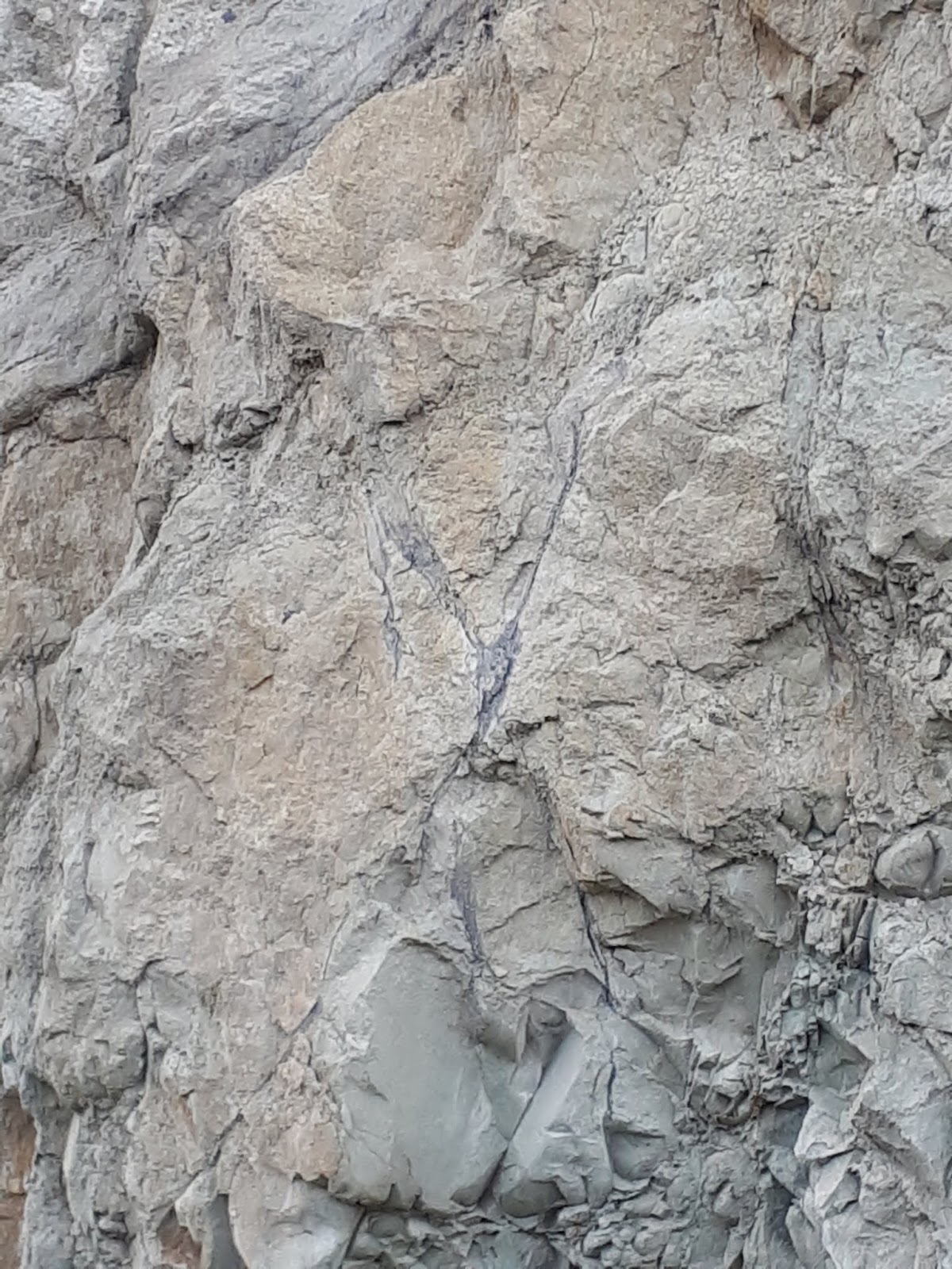
 |
| The White Lake Formation exposed in Westbank. Uplift is a result of tectonic activity. |
 | |
| Rocks are approx 45 million years old, mixture of volcanic rocks and volcanic-rich sediments. |
(Apologies the photos were taken with my phone...)
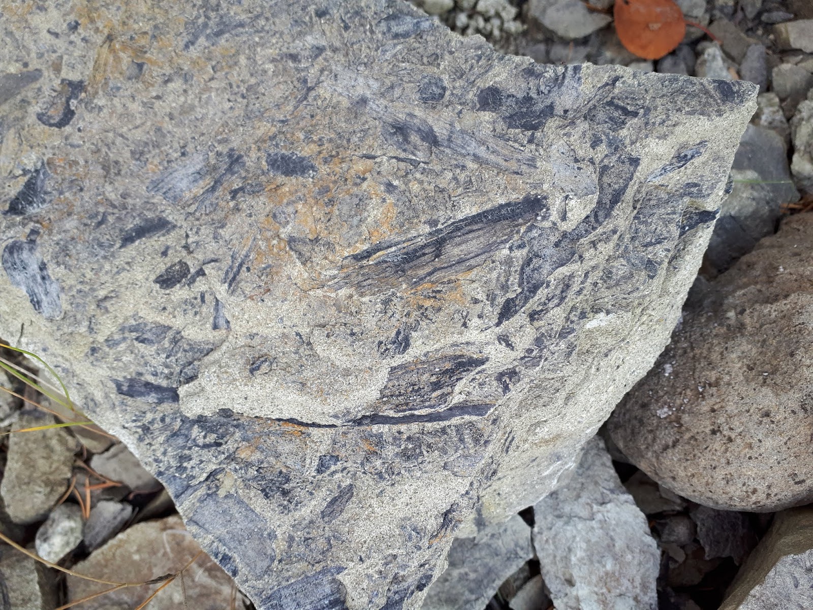
 |
| A fossilized tree in center of photo, forms a dark "Y" shape, beside muds and chaotic assemblage |
 |
| This dark sinewy structure is fossilized roots of a tree |
 |
| Fossilized tree roots |
 |
| Rock varves? (no!) Thin coal beds between sandstone / ashfall |

 |
| Dark structures within the rock are actual parts of trees...branches and stems, roots |
 |
| Thin coal seams, which erode quickly out of rock |
 |
| Two thin coal seams |
 |
| Another coal seam |
Murray Roed's book tells it so well: "Fossils of broad-leaf trees, ferns, and forerunners to modern redwood trees indicate a warm and damp, if not sub-tropical climate." (Okanagan Geology)
Ash-fall breccia?
Yes.
"Some of the rock is almost certainly a volcanic ash-fall breccia deposit because the material between clasts has the same composition as the clasts. Apparently living things in the Kelowna area had a difficult time of it during the Eocene (epoch). Floods produced raging rivers that periodically swept away or buried life in swamps. Mudflows (lahars) originating on nearby volcanic edifices buried anything in their path and explosive volcanic eruptions (recorded by the ash beds) regularly smothered everything alive. Despite a pleasant climate, natural hazards meant that this was not a nice place to live!" (Okanagan Geology)
 |
| Coal veins, with evidence of tree roots (just to the left of middle in lower third of photo) |
 |
| Coal on rocks, combined with plant parts adjacent to coal on another. |
My take-home trove in pictures!
 |
| Numerous fossils of plants: stems and leaves |
 |
| Broadleaf (deciduous) fossils |
 |
| Deciduous and coniferous fossils |
 |
| Fossil leaves (apologies for fuzzy focus) |
 |
| Many small plants, including ferns and reeds in the specimen in the foreground |
 |
| Not far from a nursery in Westbank...two feeder dikes are exposed, cutting through black shale. |

And we weren't done yet...(although I thought my head would explode from over-stimulation and the excitement of the day).
Next was to the top of Knox Mountain to view exposed bedrock on which the over-riding glacier had left striations.
 |
| Visibility of 30 miles in every direction from Knox Mountain, here looking N |

 |
| Glaciers have their own writing method on bedrock |
 |
| Note the different directions of the striations |
 |
| Striations, some at 90 degrees to previous marks. |
 |
 |
| Looking back to Dilworth Mountain (where we began our day) from Knox Mtn. |
Debra Roed invited me in to their home and showed me a "cannonball" (concretion) sample from an unknown Kelowna location.
And the tour was over!
And, yes, I drove home in a total daze...of what I had seen this day.
But would I be able to sleep tonight after all that excitement?!?
A sincere thank you to Dr. Murray Roed and Debra Roed!
I appreciate the patience they showed with this amateur.
Thank you for the myriad explanations to help this layperson appreciate the history of this beautiful area.
Having returned a mere two weeks ago from my twice a year jaunts down Hwy 97 to Wenatchee / Spokane, I'm already planning my March trip south...with a definite stop at OK Falls, just south of Penticton to poke around and see if I can find the third exposed area of White Lake Formation...
And I'll definitely pull over for a better look at McIntyre Bluff, near Vaseux Lake.
Other Reading and Notes:
Notes: British Columbia today has "18 sleeping volcanoes".
Ice Age Floods, and B.C. Melting caused Floods
Glacial Lake Missoula
Geology of the Pacific Northwest
The Decay of the Okanogan Lobe, WA state
Volcanic Suites of Southern B.C.